Stormy Saturday, heat builds this upcoming week
SUMMARY: Showers and storms once again likely for Saturday, with rain chances dropping for Sunday. The heat begins to build on Sunday and peaks by Tuesday in the upper 90s across the area as drier air looks to push in. Shower and storm chances will be very low on Monday and Tuesday. The storm chances return with a low chance of storms on Wednesday, with more typical scattered showers and storms later in the week. Highs return to more seasonable levels. No tropical threats on the horizon at the moment, but we are now in the peak of hurricane season so we’ll be watching!

SATURDAY: Widespread showers and storms likely across the area this afternoon, some could be strong with gusty winds, heavy rain and lightning. Highs in the mid to upper 80s.
SATURDAY NIGHT: Showers and storms should quickly end after sunset. Very muggy, some fog is possible later in the night. Lows in the low to mid 70s with partly cloudy skies.
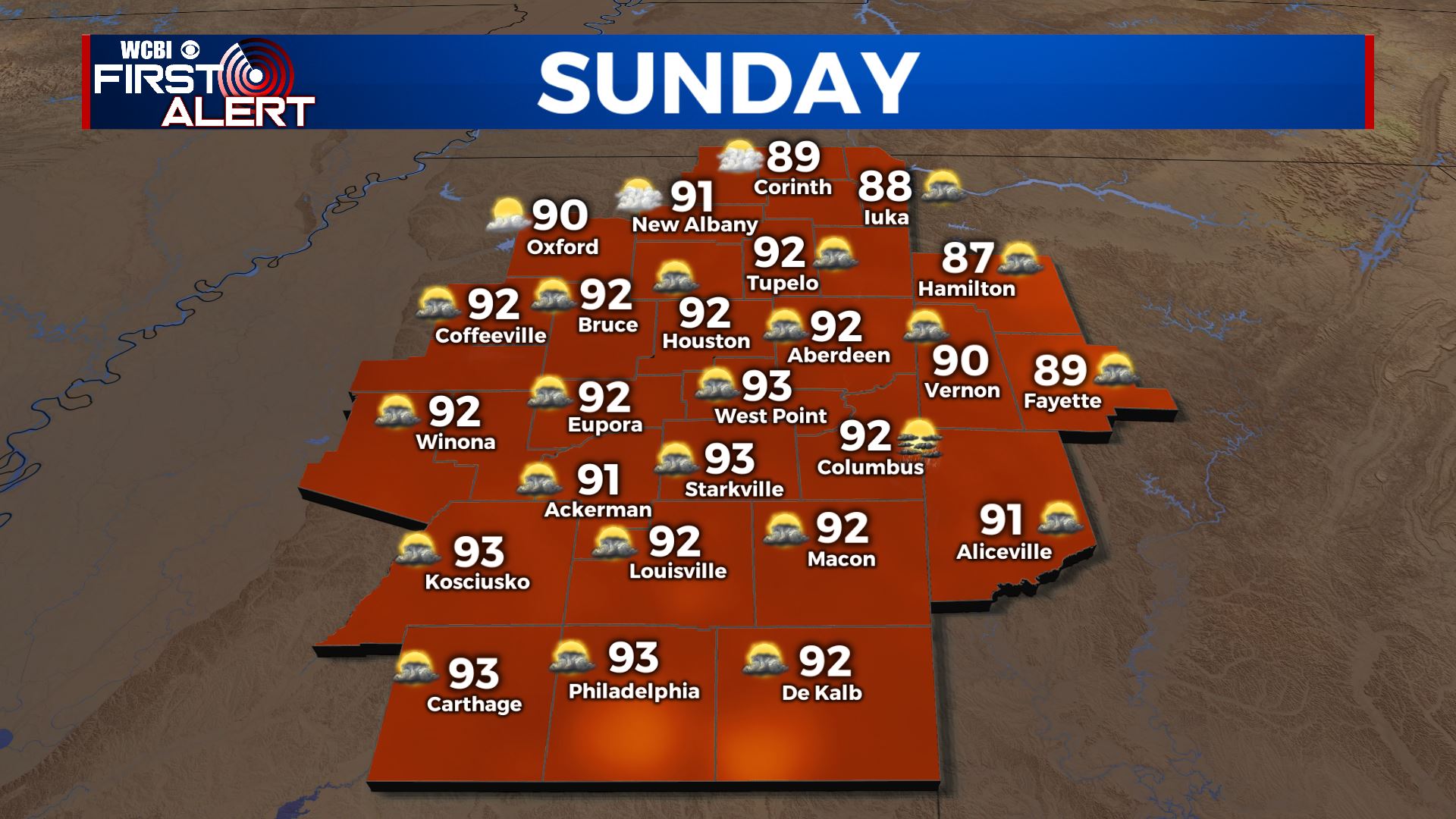
SUNDAY: Sunday looks drier, with only isolated afternoon showers and storms. Most of us should stay partly cloudy and dry. Highs warm into the low 90s.
SUNDAY NIGHT: Sunday night should be calm and clear, with lows in the low to mid 70s with partly cloudy to mostly clear skies.
UPCOMING WORK WEEK: Monday looks to completely dry out across the area, rain chances should stay very low. Skies will be mostly sunny, allowing us to reach the mid 90s in the afternoon. Tuesday looks even hotter, with highs in the mid to upper 90s under mostly sunny skies. Heat advisories likely for Tuesday and Monday, be sure to stay hydrated! Wednesday cools back down a bit into the low to mid 90s with isolated PM storms. Highs fall back to the low 90s for Thursday and Friday, which is typical for this time of year. Scattered showers and storms possible in the afternoons.
TROPICS: Hurricane Grace rapidly intensified on Friday and made landfall as a strong category 3 major hurricane in Mexico well south of Texas. It will now quickly dissipate over the mountains of Mexico. Tropical storm Henri is forecast to strike the northeast as a hurricane or strong tropical storm on Sunday, bringing flooding rain, storm surge, and high winds. No impacts expected here. Models are hinting at another storm developing in the gulf by the end of the month, so we’ll closely be watching that. No immediate threats on the horizon!
Stay connected with @WCBIWEATHER on Facebook, Twitter, Instagram and the WCBI News App