Quiet pattern for now
SUMMARY: While a slow moving area of low pressure swirls in the Carolinas, our region continues to be on the drier side of the system. Look for mostly sunny to partly cloudy skies to continue through the end of the work week. Humidity levels will come up by the weekend and that will give rise to storm chances by Sunday and early next week.
TUESDAY NIGHT: Mainly clear and quiet. Lows around 60 with light wind.
WEDNESDAY: Mostly sunny to partly cloudy. Highs in the mid 80s. Winds NE 5-10 mph.
WEDNESDAY NIGHT: Mostly clear and quiet. Lows in the low to mid 60s.
THURSDAY & FRIDAY: Mostly sunny to partly cloudy. Warmer highs in the upper 80s to lower 90s. Lows stay in the 60s.
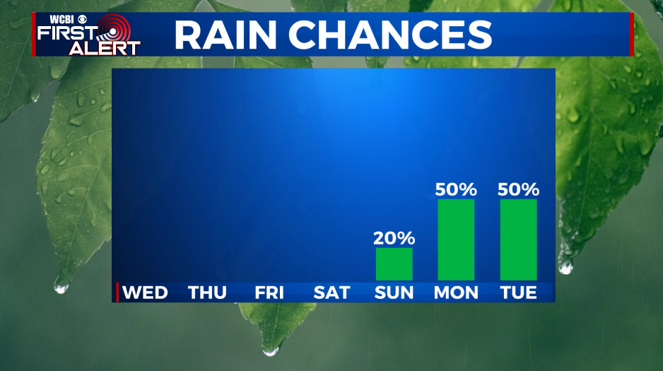
SATURDAY & SUNDAY: Humidity levels rise as temperatures stay very warm. Highs will top out in the low to mid 90s. A few spotty storms may develop during the heating of the day Sunday but we’re keeping the chance at just 20%.

EARLY NEXT WEEK: Scattered summer storms are more likely Monday & Tuesday with the chance of rain 40-50%. Highs will range from the upper 80s to lower 90s with muggy lows in the low 70s.
Follow @WCBIWEATHER on Facebook, Twitter, Instagram, and the WCBI News App


Leave a Reply