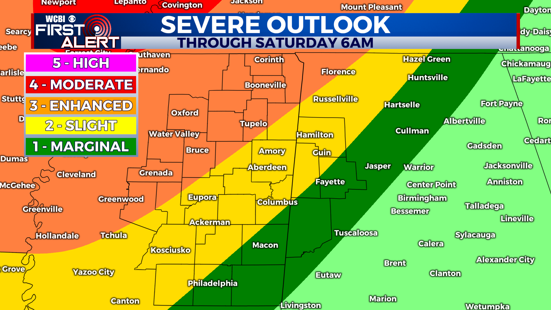
Severe weather is possible tonight and early Saturday morning
COLUMBUS, Mississippi (WCBI) – SUMMARY: A strong cold front will continue to move toward our region tonight, and severe thunderstorms are expected overnight. Here is the latest update.
TONIGHT: Isolated showers and thunderstorms before 12am, then occasional thunderstorms. Some storms may be severe. South wind 10-15 mph with gusts over 30 mph. Chance of rain: 90%.
SATURDAY: Showers and thunderstorms before noon. A few storms may be severe. Morning temperatures in the mid-60s, followed by afternoon temperatures in the low-50s. Chance of rain: 80%. South wind 5-15 mph, becoming north during the afternoon. Wind gusts up to 30 mph.
SATURDAY NIGHT: Partly cloudy with lows in the low-30s. North wind 5-10 mph becoming calm overnight.

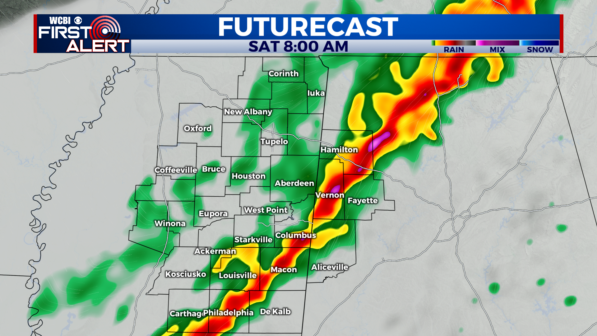
SEVERE WEATHER POTENTIAL: We are continuing to monitor the latest for this evening and overnight. We do not expect widespread impacts this evening and storms should remain isolated through the evening and early tonight. If any storms are able to develop through 11pm, they have the potential to become severe rather quickly. The greatest threat from any severe thunderstorms before 1am will be an isolated tornado or two. After 1am, the attention will turn to a cold front beginning its approach to our area. Thunderstorms are expected to develop by 2am to our northwest as upper level dynamics become more favorable for widespread convection. After 2am, a line of strong to severe thunderstorms is expected to be moving east across the region. The primary threat with this wave of severe weather will be damaging wind gusts in excess of 60 mph with a few isolated tornadoes possible.
SEVERE WEATHER SAFETY: First, a quick note about “watch vs. warning”. A Tornado Watch means conditions are favorable for tornadoes in and around the watch area. It does not necessarily mean a tornado has been detected. If a Tornado Warning is issued for your area, however, that means that a tornado has been detected by radar or has been sighted. A Tornado Warning in your area means that it is necessary to take shelter immediately in a sturdy shelter. The best place to be during a tornado warning is a site built structure (not a mobile home or vehicle) and in an interior room. The key is to put as many walls between you and the outside as possible.
If you are in a mobile home, you will want to have a plan of action that takes into account the time it will take to get to a sturdy tornado shelter or a 24 hour business. Do not wait until the last minute to know where you and your family will go in case of a tornado. Mobile homes, even modern ones, are simply not safe during a tornado and cannot be used as a form of shelter.
Tornado Safety Items: Hard sole shoes, flashlights, and helmets are important to have quickly accessible in case of a tornado. You may only have a few minutes to act to move your family to safety and it is important to be ready for rapidly changing conditions. None of us want to be looking for a pair of shoes at 3am when a tornado may be very close to your home. It is also wise to keep your phones on chargers so that you are prepared in case of a power outage. You can access our severe weather coverage through Facebook or on this page. We will maintain coverage if any tornado warnings are issued. As a note, if there is a tornado warning within our coverage area, we will stay on air no matter how populated the location is! Every home and every viewer is important to us! Whether you are in northeast Mississippi or west central Alabama, we will have you covered.