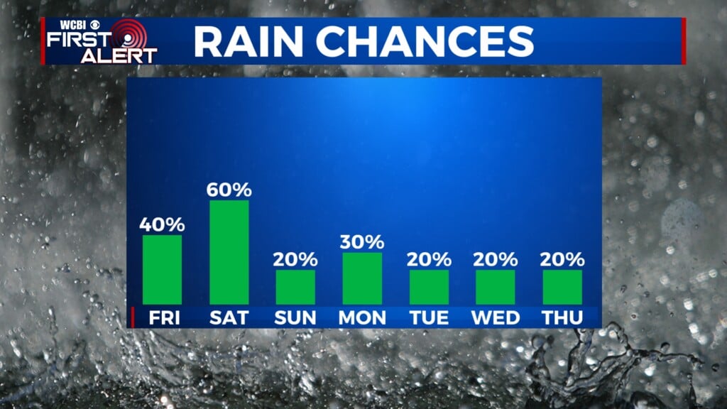
Showers and storms finish the week
COLUMBUS, Mississippi (WCBI) – There has been a nice two day break from the rain, but we knew it would not last forever. Scattered showers and potentially a few thunderstorms will finish off the week, as time rolls us into the weekend.
THURSDAY NIGHT: Clouds will keep building in through the rest of the evening. This will keep temperatures feeling a bit more muggy and mild, in the upper 60s. Rain will start up overnight in the western and SW portions of the viewing area.
FRIDAY: Rain will continue moving in from the West and SW throughout the morning and afternoon. High temperatures are going to be cooler, reaching the upper 70s to lower 80s. There may be a slight break in the rain going through late afternoon to early evening, but more showers and storms are to be expected overnight. The Storm Prediction Center has downgraded the severe risk from 2/5 to a Level 1 – Marginal Risk. Strong to severe storms are possible, with gusty winds and heavy rain being the main concern. Overnight lows will stay mild in the upper 60s.

SATURDAY: A bit more scattered, but the chance for rain will stick around for the first half of the weekend. High temps will stick to the lower 80s. Showers and a couple rumbles of thunder are possible through the evening, riding along the passing cold front.