Summer-like trends
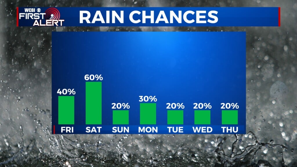
COLUMBUS, Mississippi (WCBI) – Warm temperatures with the chance for scattered showers and thunderstorms continues this week. Wednesday will be the warmest and stormiest, going into Thursday morning.
MONDAY: The morning starts off with a line of showers and scattered thunderstorms across the northern third of the viewing area. Moving in a West to East fashion, looking to clear out late morning. A chance for a few more showers continues throughout the day and into the evening. Temperatures are heading towards the middle 80s.
MONDAY NIGHT: Mild and muggy. Dew points and heavier clouds will keep temperatures in the middle to upper 60s tonight and the humidity high.
TUESDAY: A copy and paste situation. Temperatures maintain in the middle to upper 80s. The chance for rain showers sticks around, scattered across the viewing area throughout the day. Overnight temperatures remain in the upper 60s.

WED/THURS: The greatest chance for rain will be in this time period. One model shows moderately heavy showers starting off Wednesday morning across the northern third of the viewing area. Continued chance for scattered rain throughout the day. Towards late afternoon to Thursday morning, heavier showers and storms look to become likely. Severe threats could be possible, stick with us throughout the week for updates!