Warm days continue with increasing heavy rain chances
COLUMBUS, Mississippi (WCBI) – Rain chances increase through mid-week as warm days persist. Much colder air rushes in by Friday.
TUESDAY: The sky starts clear, but clouds will slowly increase through the day as moisture builds in from the south. Daytime highs will reach the mid to upper 60s.
TUESDAY NIGHT: Further moisture increases will lead to developing rain after midnight. Pockets of steady or heavy rain are likely by daybreak Wednesday.
WEDNESDAY: On and off rain is likely through the entire day. While some breaks in the wet weather are possible, plan on much of the day being soggy and breezy.
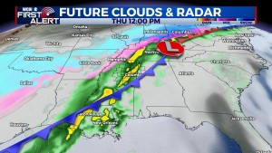
THURSDAY: A strong front and associated area of low pressure will move across the state, bringing in even higher moisture content. In fact, near-record moisture is expected, so heavier rain is also likely. For now, the most unstable air should remain just south of the WCBI coverage area, so any severe potential should be confined to I-20 southward. Still, a large shield of heavy rain should pass through the region during the afternoon. As the rain ends, much colder air will rush in from the northwest. Temperatures will drop from the upper 60s in the afternoon to near freezing Friday morning.
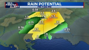
TOTAL RAIN AMOUNTS: 2-4″ of rain could fall over the span of Wednesday and Thursday. Minor flooding possible, and even a low threat of flash flooding will exist as well.
FRIDAY: Cold, mostly cloudy weather returns as highs struggle into the lower 40s. Temperatures will drop into the 20s Friday night.
WEEKEND: A brief break in the action is expected Saturday, but yet another disturbance could generate rain for Sunday…primarily over Alabama. Highs both days will be near 50 degrees.


Leave a Reply