Warm Thursday ahead of unsettled weekend
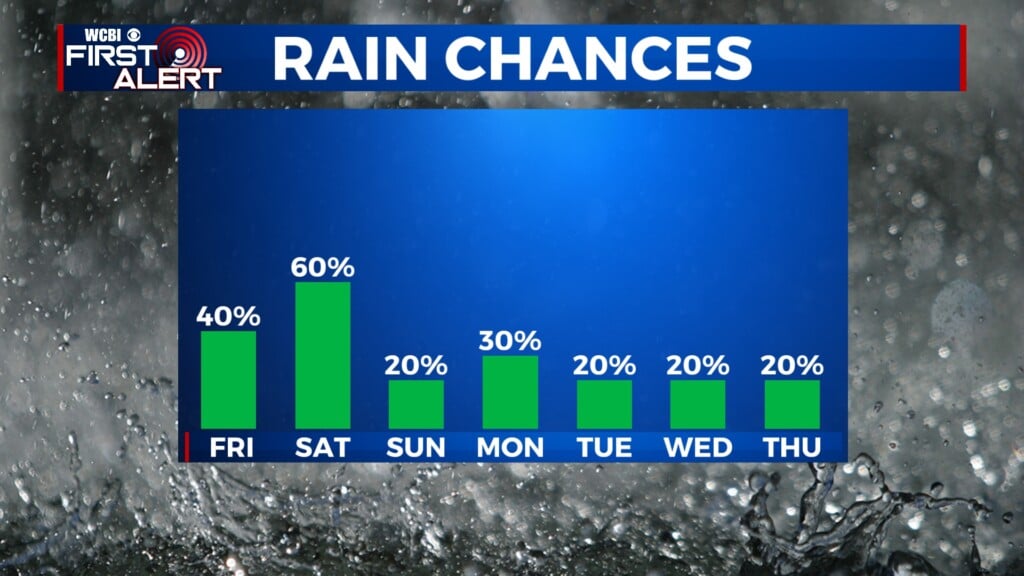
COLUMBUS, Mississippi (WCBI) – Temperatures stay in the upper 80s Thursday ahead of several days of rain chances.
THURSDAY: Expect more filtered sun thanks to persistent high cloudiness through the day, but highs should still reach the upper 80s. A few late-day downpours or storms are possible, but the more widespread activity should stay over south Mississippi into Louisiana.
THURSDAY NIGHT: Isolated showers and a storm or two stay possible overnight with lows in the middle 60s.
FRIDAY: We still expect some dry time during the day, but confidence is a little higher in periods of steady to heavy rain as well. Specific timing is still uncertain, so stay tuned as we update the forecast!

WEEKEND: Saturday’s rain coverage still looks to stay isolated much of the day, allowing highs to inch back into the middle 80s. Scattered showers and storms are a bit more likely Sunday.
NEXT WEEK: The focus will shift toward building heat & humidity levels into mid-week. We’re likely to have our first official 90 degree day Wednesday, and there’s concern of growing storm potential Wed-Fri across the Mid-South as well.