Warm, windy Thursday with severe storms expected
COLUMBUS, Mississippi (WCBI) – Warm, humid weather leads to severe weather chances Thursday afternoon. Much colder air returns for Friday.
THURSDAY: The day stays warm and very windy with highs in the middle 70s and southerly wind gusts up to 40 mph outside any thunderstorms. A wind advisory remains in effect for this potential. Otherwise, sporadic showers are possible in the morning hours with a mostly cloudy sky. Peeks of sun are expected through the day, and showers and storms will gradually strengthen and develop into northeast MS and west AL by afternoon. These storms will be capable of damaging wind gusts over 60 mph and tornadoes. Given the enhanced wind shear and potential energy available for storms, an isolated strong (EF2+) tornado is possible. The greatest threat window appears to be between 2-5pm.
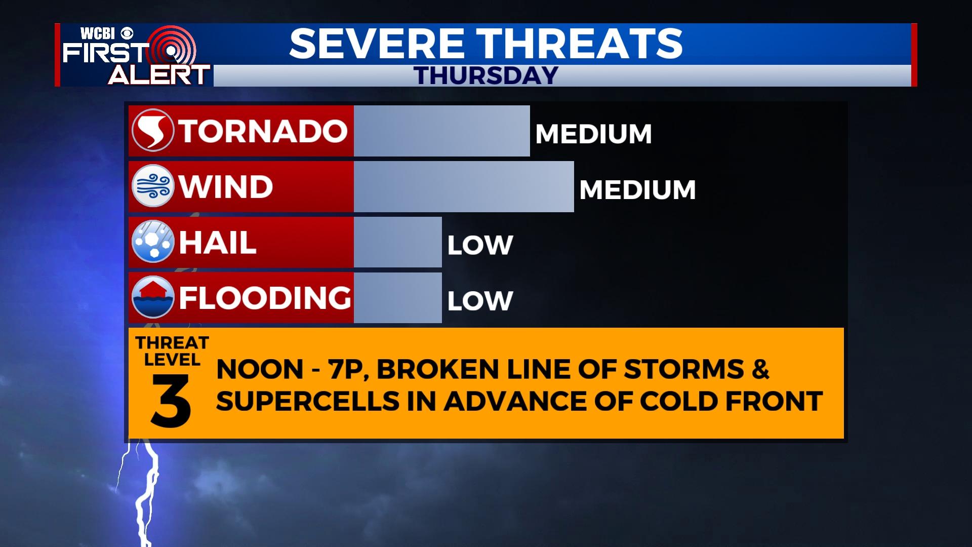
THURSDAY NIGHT: Storms should move out of the area by 7pm, and much colder will rush into the region behind a cold front. Temperatures will plunge into the 30s or even upper 20s by daybreak Friday. Wind chills will range from 18-28 degrees.
FRIDAY: The day starts cloudy, but drier air will eventually filter in and sunshine will return. Highs will struggle to reach 50 degrees ahead of a colder night.
WEEKEND: Saturday morning starts in the 20s, but full sunshine warms the afternoon to near 60 degrees. A decent day is on tap Sunday as well with highs in the mid 60s.
NEXT WEEK: An unsettled, potentially active pattern looks to set up across the Mid-South. A stationary front with multiple disturbances could spell repeated rain chances Monday-Wednesday. Severe weather potential looks low at this point, but rounds of heavy rain could lead to a flooding risk. Stay tuned for further updates on this potential!
SEVERE WEATHER SAFETY: First, a quick note about “watch vs. warning”. A Tornado Watch means conditions are favorable for tornadoes in and around the watch area. It does not necessarily mean a tornado has been detected. If a Tornado Warning is issued for your area, however, that means that a tornado has been detected by radar or has been sighted. A Tornado Warning in your area means that it is necessary to take shelter immediately in a sturdy shelter. The best place to be during a tornado warning is a site built structure (not a mobile home or vehicle) and in an interior room. The key is to put as many walls between you and the outside as possible.
If you are in a mobile home, you will want to have a plan of action that takes into account the time it will take to get to a sturdy tornado shelter or a 24 hour business. Do not wait until the last minute to know where you and your family will go in case of a tornado. Mobile homes, even modern ones, are simply not safe during a tornado and cannot be used as a form of shelter.
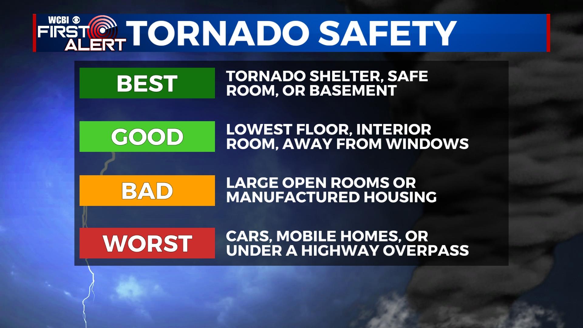
Tornado Safety Items: Hard sole shoes, flashlights, and helmets are important to have quickly accessible in case of a tornado. You may only have a few minutes to act to move your family to safety and it is important to be ready for rapidly changing conditions. None of us want to be looking for a pair of shoes at 3am when a tornado may be very close to your home. It is also wise to keep your phones on chargers so that you are prepared in case of a power outage. You can access our severe weather coverage through Facebook or on this page. We will maintain coverage if any tornado warnings are issued. As a note, if there is a tornado warning within our coverage area, we will stay on air no matter how populated the location is! Every home and every viewer is important to us! Whether you are in northeast Mississippi or west central Alabama, we will have you covered


Leave a Reply