Weekend warm up
COLUMBUS, Mississippi (WCBI) – Stationary front has keep the moisture around, but warmer air is about to take over. This will bump high temps up for the end of the week and the weekend!
THURSDAY NIGHT: Clouds will be sticking around pretty heavily tonight. The clouds will be holding in some of the warmth from the day. Temperatures tonight will be mild because of this, dropping only into the lower 60s.
FRIDAY: There will be a mix of sunshine and clouds through the day. The breeze will pick up during the evening. Highs will easily reach the 80s, likely reaching the middle 80s for some.
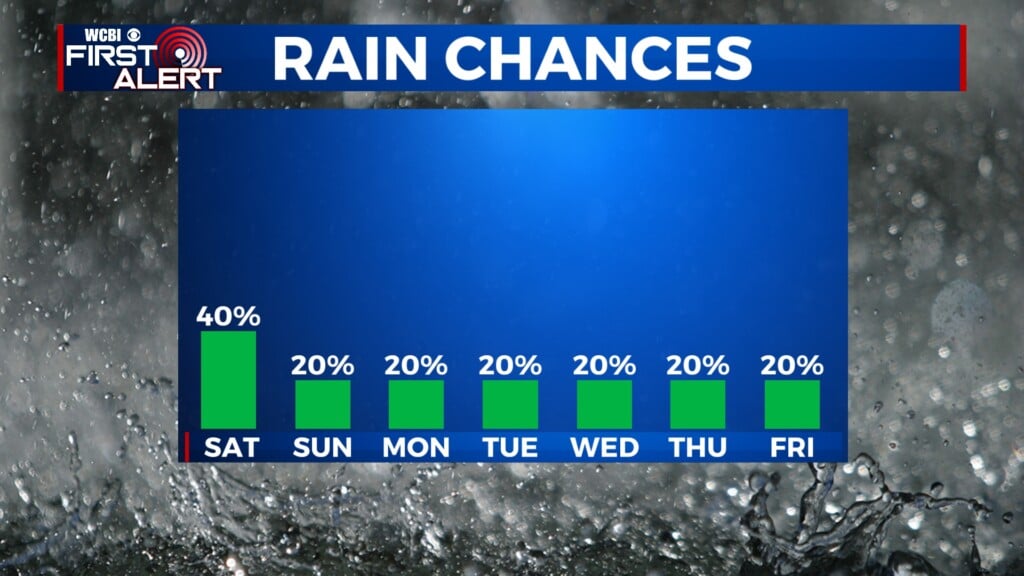
WEEKEND: Afternoon highs will maintain in the middle 80s Saturday & Sunday, with limited to no rain expected. There could be a rogue shower or two along the way, but interrupting-type rain is not expected. Mild lows will be continuing in the low to middle 60s.
NEXT WEEK: Monday continues highs in the 80s, but also brings in the next chance for showers and thunderstorms. Some could see heavy amounts of rainfall. Not looking at a severe risk, for now. Keep updated with us through the weekend! Light rain chance will then continue throughout the week. Highs will range from the upper 70s to the middle 80s.