Another Arctic blast
COLUMBUS, Mississippi (WCBI) – While temperatures warmed up today, the front will pass tonight and Arctic air will come filling back in for round two. However, we just have to get through the weekend before conditions flip the script.
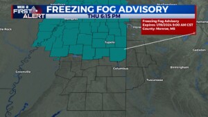
THURSDAY NIGHT: Into this evening, freezing fog could develop ahead of the approaching cold front. A FREEZING FOG ADVISORY has been issued for many of our northern counties until 9am Friday morning. This will be a lot like our normal looking fog. But because of the rain and close to freezing temperatures, new icy conditions could develop on bridges/overpasses. The movement of this boundary will help clear out the last of the scattered rain in NE MS. Once the front passes, cold Arctic air and gusty winds will be quick to happen. Temperatures tonight will still be cold, dropping into the 20s and lower 30s.
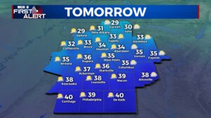
FRIDAY: With very slow clearing of the clouds, temperatures will struggle to reach above freezing. Thanks to round two of the Arctic air, high temperatures for the end of our week will only reach into the middle 30s. Conditions will be overall dry though! By Friday evening, most of the cloud coverage should clear. Overnight low temperatures will then fall quickly into the middle teens. A HARD FREEZING WARNING has already been issued for the southern half of our viewing area, going from 6PM Friday evening to Noon Sunday afternoon.
WEEKEND: Saturday high temps will be back to below freezing! The high is only excepted to reach the upper 20s, maybe the lower 30s. The sky will be clear and filled with sun! Temperatures will be falling back into the low to middle teens Sunday morning, before working their way back into the lower 40s Sunday afternoon.
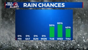
NEXT WEEK: Plot twist! Conditions are going to nearly flip, going from below average to above average. There will be a steady climb in temperatures, going through the 50s and quickly into the 60s. Looking at maybe even the lower 70s by the end of the week. Rain chance will be filling back in and across northern Mississippi beginning late Monday night and continuing for several days.


