Clear and dry skies allow for gradual warming early in week
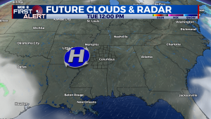
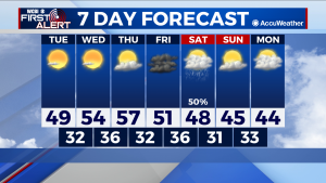
COLUMBUS – SUMMARY: Dry conditions prevail over the next few days until our next cold front on Saturday. Mostly clear skies due to high pressure during this dry period will contribute to some gradual warming back into the high 50s by Thursday. Lows remain relatively consistent in the 30s, aided by the aforementioned cold front on Saturday.
TUESDAY: Highs approach 50 Tuesday afternoon as our gradual warming trend continues. Mostly clear skies and dry conditions tag along, further enhancing the environment for warming to occur. Lows bottom out at or below freezing for the third night in a row.
WEDNESDAY: We break into the mid 50s on Wednesday as those clear and dry conditions continue to remain in the region. Lows improve slightly into the mid to high-30s overnight.
REST OF THE WEEK: The clouds do gradually return starting on Thursday, which will put a damper on the warming trend that had been occurring. Highs will maximize in the upper 50s by Thursday before a combination of the previously mentioned clouds and Saturday’s cold front brings temperatures back into the mid to upper-40s for our highs and lower 30s for our lows. A notable rain chance does exist with Saturday’s front but the potential for impacts other than rain appears to be low at the moment.


