Dry Thursday and Friday, tropical threat for the weekend
SUMMARY: A dry Thursday and Friday in store, albeit with increasing humidity on Friday. Rain chances quickly return for Saturday as we watch the developing tropical system in the gulf. There is still a good amount of uncertainty in the track of the system, as it still hasn’t formed. Until it forms and has a well defined center of circulation, track forecasts won’t be as accurate. For now, expect a wet weekend, with cooler temps due to cloud cover. Models aren’t agreeing on where exactly it will go- a more easterly track would mean less impacts to our viewing area, while a more westerly path through the gulf would mean more impacts. The system should be out of the area by Sunday night, but remaining moisture and a frontal boundary means we stay unsettled into the workweek.
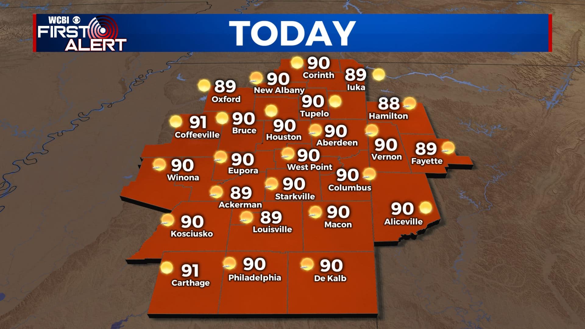
THURSDAY: A sunny and dry day in store once again for your Thursday. Expect mostly clear skies through the afternoon and a high near 90 degrees.
THURSDAY NIGHT: A bit less refreshing for Thursday night, with a slight increase in humidity and warmer lows than the previous 2 nights. Clear skies continue, lows in the upper 60s.
FRIDAY: A warmer day in store for Friday, with more clouds in the afternoon as well from the approaching tropical system. Highs in the low 90s with increasing humidity.
FRIDAY NIGHT: Widespread cloud cover moves into the area starting Friday night, returning our lows to seasonal norms around 70 degrees. Rain showers could begin to push into the area late in the night.
SATURDAY: A lot of uncertainty in Saturday’s forecast. We know the tropical system will be nearby, and it seems a good bet someone in the viewing area will get a lot of rain. All depends on track, a more westerly landfall puts more of us in line for heavy rainfall Saturday. Either way, expect a cloudy day with high chances of showers and storms, highs in the mid 80s.
SUNDAY TO WEDNESDAY: The tropical system, Claudette if it gets named, will linger over the area into Saturday night. It should be mostly East of us by Sunday, but lingering moisture will keep rain chances elevated through Sunday afternoon. Highs staying in the low to mid 80s. A frontal boundary will approach the area beginning Monday, and with the remaining tropical moisture scattered to numerous showers and storms look likely for Monday and Tuesday. Highs staying in the low to mid 80s, lows around 70. Wednesday could have reduced rain chances, but for now thinking we’ll see more scattered afternoon storms. Highs in the 80s, lows in the mid to upper 60s. By the time all is said and done, some parts of the area could see 5-10″ of rain, once again highly dependent on track. Stay tuned, we should be able to fine-tune the details a bit more by the weekend.


Leave a Reply