Drying out before next storm chance
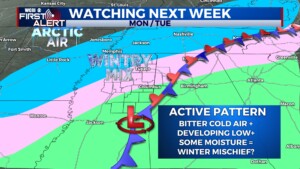
COLUMBUS, Mississippi (WCBI) – Tuesday was kind of gross, just cloudy and cold. The middle of the week will become drier and warmer. End of the week brings in the next chance for showers and storms. Early next week will be controversial, with the chance of bringing in a wintry mix to NE MS.
TUESDAY NIGHT: Clouds will be slow to clear out, but the temperatures will be quick to drop. Overnight low temperatures will be sub-freezing, middle 20s to lower 30s.
WED/THURS: The best days to get out and enjoy nicer conditions. Wednesday’s temps will be tolerable, in the lower 50s during the day. Conditions will be clear and sunny! Overnight temps will be cold again, in the low to middle 30s. Thursday will be warmer, highs in the lower 60s and lows in the upper 40s. Cloud coverage will fill back in becoming partly cloudy during the afternoon and mostly cloudy by the evening. There will be a light chance for rain Thursday evening.
FRIDAY: Our next major system will be bringing in heavy showers and thunderstorms for the end of our week. Moisture from the Gulf will meet with the passing boundary over Louisiana and Arkansas. There is a chance of some storms becoming strong to severe. The Storm Prediction Center has already placed a Level 2 – Slight Risk for severe weather over Mississippi. This will be a quick moving system, allowing for temperatures to drop into the upper 20s Friday night.
SAT/SUN: Saturday will be chilly but clear and sunny, high temps in the middle 40s. Sunday will be slightly warmer, reaching back into the lower 50s. Overnight lows will fall to sub-freezing temperatures again, in the middle to upper 20s. Cloud coverage will increase throughout our Sunday, with a light chance for precipitation overnight.
NEXT WEEK: Confidence is not high. Remembering, it is still a week away and weather is constantly changing. Okay… There is a chance of seeing a wintry mix of precipitation early next week. Sleet and possibly snow could be included. Temperatures will be at their coldest Monday and especially into Tuesday. Road ways could become icy, as lows look fall into the teens. Since we are speaking on this so early, totals and exact timeline are not going to be mentioned. This does not mean everyone needs to run and buy a month’s worth of bread and milk right this second…Just prepare mentally first. More details will be provided as time goes on and confidence increases.


