Heat builds the next few days
COLUMBUS, Mississippi (WCBI) – As a ridge of high pressure expands across the Southeast, each afternoon will get hotter into the weekend.
THURSDAY: Expect more sunshine than recent days, thanks in part to TS Alberto finally moving west into Mexico. Afternoon highs should reach the lower 90s area-wide, making it a bit hotter than previous days as well.
THURSDAY NIGHT: Mostly clear and pleasant’ish – expect overnight lows in the upper 60s to near 70°.
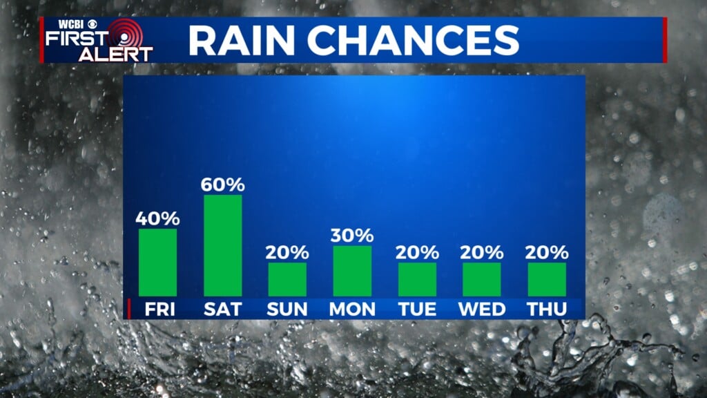
FRI/WEEKEND: Mostly sunny and dry weather holds for the weekend, as does the dry weather. Expect highs in the mid 90s Friday and upper 90s Sat/Sun. There may be a few areas getting close to 100 degrees by Sunday, with heat indices likely approaching 105°.
NEXT WEEK: We finally get better moisture back by Monday, and with the approach of a weak front, we should see an increase in scattered showers and a few storms Mon-Wed.

TROPICAL UPDATE – TS Alberto is set to make landfall Thursday morning along the coast of Mexico, near Tampico. Rapid weakening is expected, but additional tropical development is possible over the weekend, once again in the SW Gulf.