Saturday night storm potential
COLUMBUS, Mississippi (WCBI) – Calm before the storms roll in Saturday night. But once it moves out, expect it to really feel like Fall.
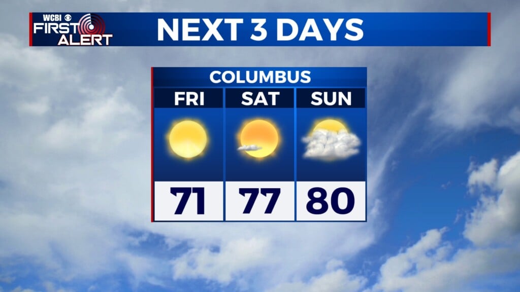
FRIDAY NIGHT: Clouds are slowly going to continue trickling in overnight and into the morning. As moisture builds in, overnight lows aren’t going to be as cool. Temperatures overnight will be mild, in the middle 60s.
SATURDAY: Staying dry, building in more moisture and clouds, with another round of roasty temperatures. Expect the afternoon highs to hit the upper 80s to lower 90s again. Feeling slightly warmer due to the increased humidity. Most of the day will be plenty enjoyable!

SAT. EVENING-SUN MORNING: The cold front will be pushing into NW Mississippi by the early evening. There is a chance for a few pre-frontal showers. The main event looks to reach our western counties around 8PM. This broken line will track West to East across the corner into western AL, hoping to clear by 5AM. There is a Level 2 – SLIGHT risk for severe weather across the NW half of the coverage area. The Level 1 – MARGINAL risk is across the SE half. Damaging wind is our highest concern with these storms. After being in extreme levels of drought, it will be easier for trees to fall. Tornado threat is not zero.
As this is an overnight event, we strongly encourage you to have alerts turned on your phones. Also, have other ways to receive your watches and warnings. You want them to wake you up, in case of danger.

REST OF SUNDAY: The wind will shift, pulling cooler and drier air into the Deep South. Clouds will clear through the rest of the day. High temperatures are going to definitely feel like FALL, reaching the middle 70s. A regional High Pressure will move in to help keep conditions nice throughout next week.