Scattered rain, storms return to the forecast Thursday
SUMMARY: After a string of hot and dry days, a more summertime weather pattern will return to north Mississippi and west Alabama over the next several days. The tropics continue to look active, and a system in the Gulf is increasingly likely late this weekend.
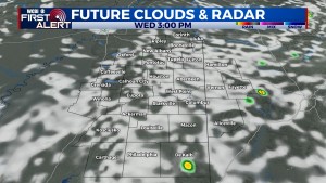
WEDNESDAY: The weather stays hot and humid with highs in the 90s and heat indices of 98 to 104 degrees for most spots. The I-55 corridor will once again see heat indices potentially over 105 degrees, and a heat advisory remains in effect until 7 PM for Yalobusha, Carroll, Grenada, and Montgomery counties.
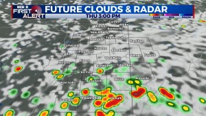
THURSDAY: The heat levels back off slightly as scattered showers and storms become more likely in the afternoon hours.
FRIDAY-WEEKEND: Isolated to scattered showers or storms remain possible each afternoon with day time highs in the upper 80s to near 90 degrees.
NEXT WEEK: The local forecast will depend on the potential track or evolution of whatever develops into the western Gulf. We’ll keep you posted in the coming days as tropical development seems likely in the western Caribbean, and ultimately, the western Gulf.


