Severe storms possible Wednesday
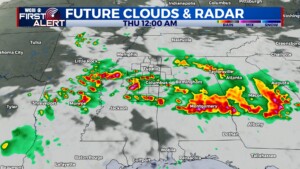
COLUMBUS, Mississippi (WCBI) – A few rounds of strong to severe storms are possible Wednesday & Wednesday night. Additional storm chances will continue into the weekend.
WEDNESDAY: Locally strong to severe storms are set to develop into northern MS later in the morning hours/lunch. These will be moving into an environment increasingly favorable for severe weather. As these move across the area, potential will exist for new storms to build on the western flank of the storm cluster back over central MS or even eastern AR into the mid afternoon hours. Some storms will be capable of significant hail/wind (2″+ in diameter, 70+ mph gusts) primarily, though a tornado or two cannot be ruled out. If current trends hold, storms may be moving out of the area and/or diminishing by mid-evening.
THURSDAY: A relatively quieter weather day is expected as we are caught in between shortwave troughs. Outside of a few showers or storms in the afternoon, most spots will stay dry with highs in the 80s.
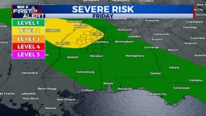
FRIDAY: Another complex of storms is set to affect the Mid-South, likely in the afternoon or evening. Storms are likely to develop upstream in Arkansas & Missouri and dive southeast. Damaging wind & hail would be the primary concerns.
WEEKEND: The active weather pattern continues! Temperatures will inch up toward 90 degrees, but scattered, locally strong to severe storms remain possible each afternoon.
