Storms return today, some may be strong
COLUMBUS, Mississippi (WCBI) – Storms will fire back up this afternoon, with a couple possibly becoming severe. The chance for stormy afternoons and scattered morning showers does not look to ramp down any time soon.

TODAY: Moisture and clouds build in through the day. Highs in the upper 80s, once we hit the hottest part of the day expect scattered showers and storms to pop up, before a more widespread line moves through this evening. A few storms could be strong to severe, and we have a level 1/5 severe risk. Unfortunately, the tornado threat is not zero, but the primary concern would be damaging winds.
TONIGHT: Storms look to continue late into the evening, finally fizzling out after midnight. A warm and muggy night is ahead, with lows in the low 70s and lots of cloud cover.
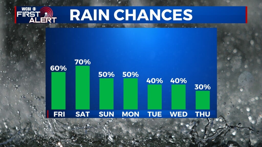
FRIDAY: Like clockwork, once we reach into the upper 80s expect storms to fire up. Another, more organized line may move through after initially scattered storms develop. Highs in the upper 80s, with little sunshine in the afternoon.

BEYOND: Temps hold in the upper 80s and rain chances hover around 40/50% for the foreseeable future. Most of us will see a good deal of rain, especially those caught under thunderstorms which could quickly drop a couple inches of rain, just to repeat the cycle the next day.