Warm, breezy Wednesday with late-evening storms
COLUMBUS, Mississippi (WCBI) – Storm potential increases late Wednesday with drier air moving in by Friday.
TUESDAY NIGHT: Expect a mostly cloudy, MUGGY overnight with lows near 70 degrees…reminiscent of a June or July night.
WEDNESDAY: Most of the day looks dry with a mix of sun & clouds. Southwest winds gusting up to 20-25 mph will help temperatures climb into the upper 80s and low 90s area-wide, with heat index numbers pushing 92-94 degrees.
WEDNESDAY NIGHT: Areas of showers and storms will eventually push into northwest and northern MS closer to midnight and into the overnight. Severe weather remains a possibility with hail & damaging winds the primary concern. The tornado threat is not zero, but this threat appears more conditional on any storm able to stay at least semi-discrete.

THURSDAY: Storms may be ongoing early in the day, but most areas look to dry out for the rest of the day as the actual front passes through. Expect another warm, humid day…but any storm potential should shift into south-central MS by afternoon and evening.
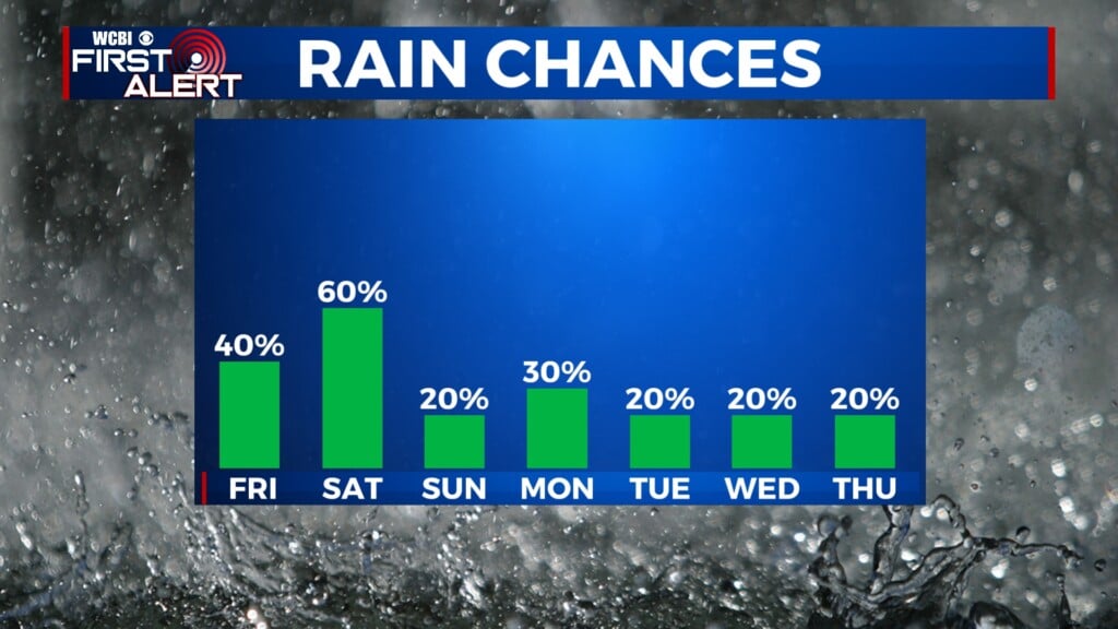
FRI/WEEKEND: At least partial clearing behind Thursday’s front is expected, but most importantly, DRIER air moves into the area! More pleasant conditions stick around through the weekend w/highs back in the 70s. Isolated showers return Sunday.