Severe Storms Anticipated Later Today
Severe thunderstorms are anticipated in the region later on today. These storms will be capable of damaging winds, large hail and a few tornadoes.
WATCH THE LATEST WCBI WEATHER WEBCAST HERE.
GET INFORMATION ON STAYING SAFE DURING SEVERE WEATHER HERE.
TODAY: This morning, expect a mostly cloudy sky with mild temperatures in the 60s. A few showers will be possible in the region, though most stay dry. Highs today climb into the low 70s in the afternoon with breezy south winds as high as 20 to 25 mph at times.
Later on this morning into the afternoon and evening, a batch of strong to severe storms will develop and move into the region. The current time-frame is from 11AM to 11PM. We’ll likely see a combination of storm clusters and potentially isolated storms. While cloud cover will help keep thunderstorm energy a bit lower, still we anticipate some robust storms to form. The tornado threat will be conditional, and depend on how storms evolve. Any isolated storms ahead of the main line would have an enhanced tornado potential, while a broken squall line may also help to produce a few rotating updrafts.
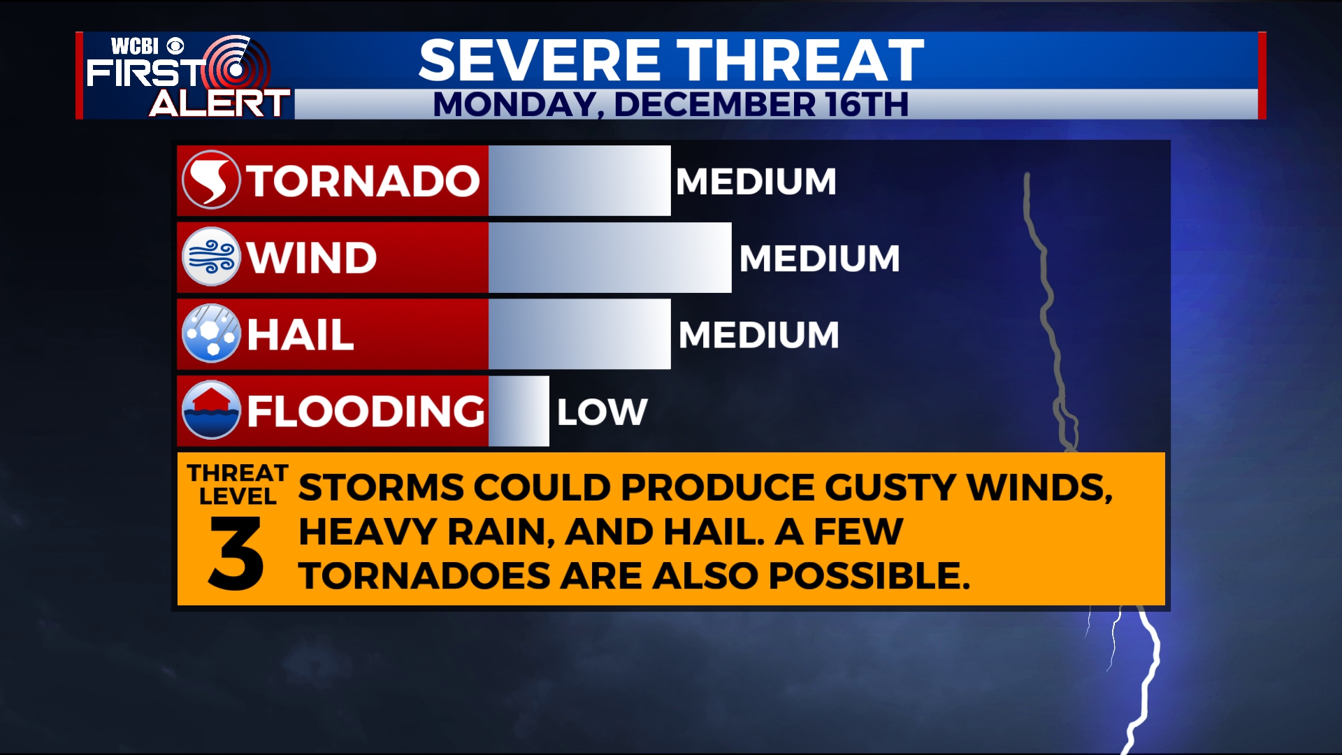
There still remains uncertainty with how storms will evolve today. The main threat advertised continues to be for damaging winds, but the tornado potential will be monitored closely during the day. As of 4 AM, we continue to advertise a level 3 risk (3/5) areawide, with perhaps the better odds for more robust severe storms along and south of US-82.
TONIGHT: By tonight, the cold front pushes through, diminishing storms and pushing them to the east. We’ll see a quick drop in temperatures and winds shift out of the north and west between 5-15 mph, perhaps with gusts as high as 25 mph. Lows fall quickly into the upper 30s and low 40s.
TOMORROW: Clouds will linger through most of the day. Some areas of sunshine may mix in, but it is expected to remain a cold and dreary day. We anticipate rain to be out of here, but perhaps a few sprinkles can’t be ruled out somewhere. Look for highs only in the 40s, with temperatures falling after sunset again. Lows Tuesday Night drop into the mid to upper 20s.
WEDNESDAY – THURSDAY : Look for a mostly sunny sky with clouds increasing Thursday Afternoon and Evening a bit. We’ll keep things dry and see highs in the upper 40s and low 50s. Lows at night are in the 20s and 30s.
FRIDAY – THE WEEKEND: We’ll likely see a mix of sun and clouds through the period, with perhaps more clouds than not. A few isolated showers can be anticipated, but we don’t expect severe weather right now.
Follow WCBI Weather on Facebook, Twitter, and Instagram and download the WCBI Mobile App.


Leave a Reply