A nice day for Wednesday followed by a cold front for Thursday
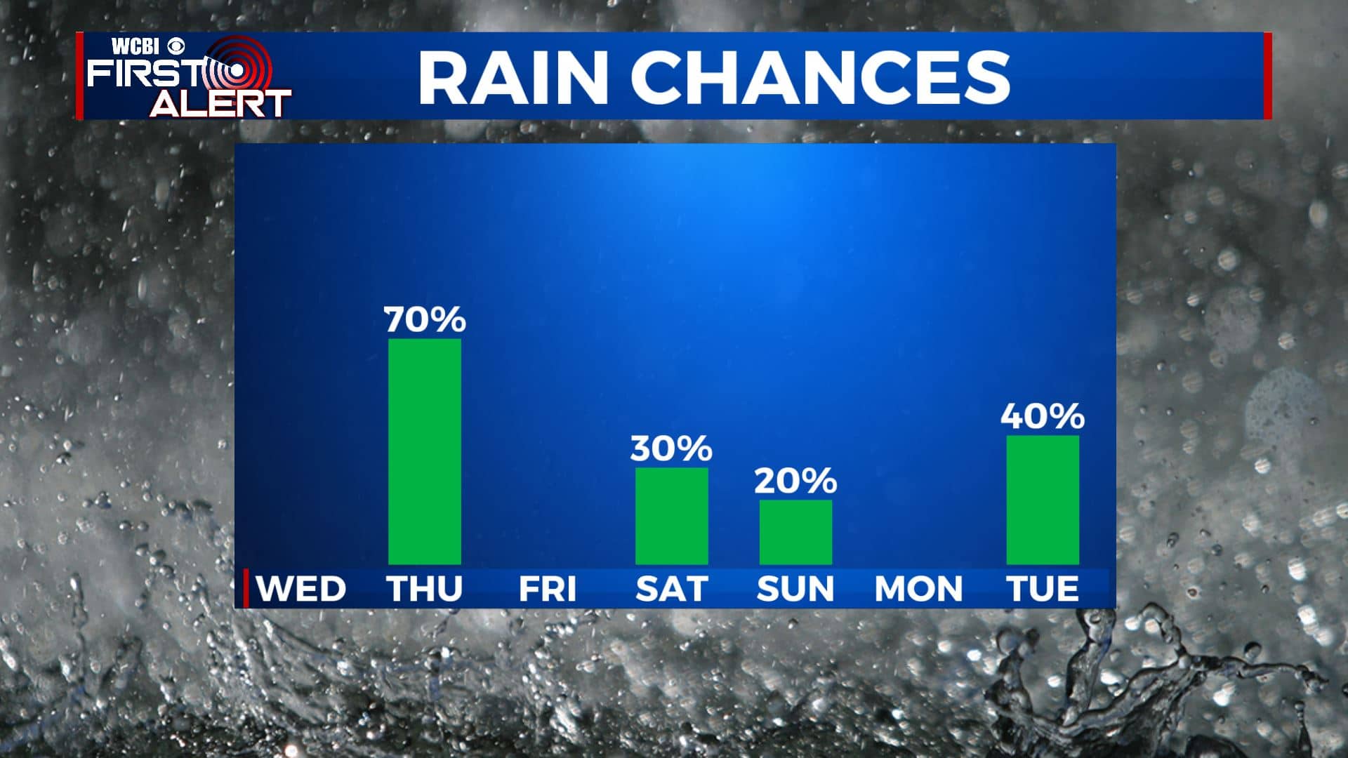
SUMMARY: A beautiful Wednesday is ahead for north Mississippi and west Alabama. A roller coaster ride of temperatures will continue over the next week along with rain chances thanks to a few cold fronts heading our way. The first round will occur late Thursday into early Friday. The second round will occur late Saturday into early Sunday. The latest data is backing off on the extremely cold air we’ve had in the forecast for Sunday and early next week. As of right now, we’re looking to stay in the 40s and 50s for highs. We’ll continue to watch and fine turn the forecast if needed.
WEDNESDAY: Another quiet weather day is ahead for us. We’ll have mostly sunny skies throughout the day. Temperatures a tad warmer with highs in the 50s as our winds switch NE/SE. Enjoy the sunshine while it lasts!
WEDNESDAY NIGHT: Increase in cloud cover. Lows in the mid 30s.
THURSDAY: Mostly cloudy, breezy, and milder. Highs in the lower 60s. Winds SSE 10-25 mph with some higher gusts possible. Some late afternoon and evening rain is possible as a cold front pushes through the region.

THURSDAY NIGHT: Cloudy with areas of rain. Lows in the upper 30s.
FRIDAY: Skies will be clearing out Friday morning, making way for a nice afternoon with sunshine. It will be cooling down a bit with highs in the lower 50s.
SATURDAY: Mostly cloudy with a chance of showers in the evening. Highs in the mid 50s.
SUNDAY: Morning showers will lead way to improving conditions by the afternoon. Another cool down behind the next cold front. Highs in the upper 40s.

MONDAY: A mix of sun & clouds. Highs around 50.
TUESDAY: Another round of rain chances return to the forecast. Highs in the mid 50s.
Stay connected with @WCBIWEATHER on Facebook, Twitter, Instagram, and the WCBI News App


Leave a Reply