Severe storms possible Tuesday evening, cooler Wednesday
COLUMBUS, Mississippi (WCBI) – Another potentially active weather day is in store Tuesday evening. Cooler air temporarily returns Wednesday.
TUESDAY: Warm, windy, and increasingly humid weather headlines the forecast today. Afternoon temperatures should reach the upper 70s, and with dew points in the upper 60s, the heat index could actually surpass 80 degrees at times. This warmth and humidity will ultimately lead to developing storms after 4 PM across northeast to central MS. Due to moderate to strong instability, these storms may strengthen quickly; however, questions remain as to the exact evolution of storms due to better shear moving out to the northeast. Having said that, sufficient shear along with instability will promote all modes of severe (hail, wind, isolated tornado) in the thunderstorm activity.
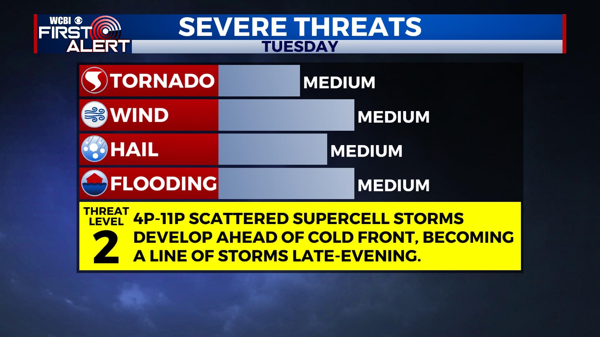
TUESDAY NIGHT: Showers and storms should persist into the evening hours, developing south/southwest along shrinking instability axis. Deep moisture and slowing storm motions/training may promote an increase in flash flood risk across areas vicinity of the US 82 corridor. The severe weather risk will likely decrease after 10p thanks to weakening instability and shear along with a surging front.
WEDNESDAY: That surging front will become more diffuse as it passes to the south of the region, loosening the temperature gradient somewhat. Temperatures may range from the upper 40s in the north to low 60s south of US 82 with widespread cloud cover. Spotty rain is also possible.
THURSDAY: Another, stronger system should pull that diffuse front back north as a warm front during the day. Temperatures will jump back into the 70s as a result with most of the day staying dry. Showers and embedded thunder will arrive in the evening and overnight hours, but severe weather concerns remain quite low this time around.
FRIDAY: We’ll get a chance to dry out behind Thursday’s system, but more activity is expected over the weekend. Highs will only reach the 50s.
WEEKEND: Unsettled weather looks to continue as an active westerly jet stream lurks overhead. This will translate to another round of rain Saturday and potentially Sunday morning.


Leave a Reply