Severe storms possible Wednesday evening/night
SUMMARY: Several rounds of storms are in the forecast over the next few days with severe weather and heavy rain a concern once again. Rainfall amounts through Saturday could end up in the 2-4” (or more) range.
TUESDAY NIGHT: Partly cloudy. Lows in the upper 50s. Winds S 3-7 mph.
WEDNESDAY: Breezy and warm. Highs around 80. Southerly winds 10-25 mph with higher gusts possible.
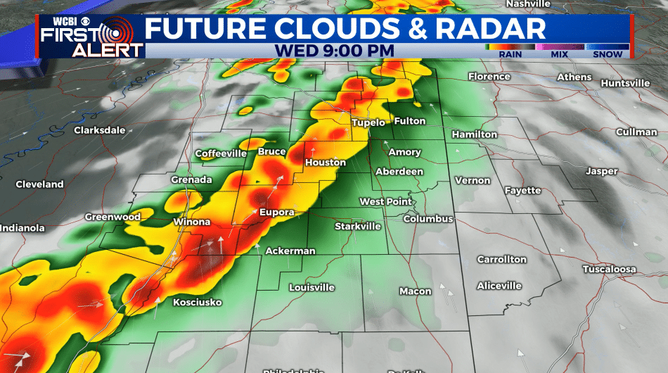
WEDNESDAY EVENING/NIGHT: A line of strong to severe storms is expected to push across the area from about 7 PM through 2 AM. Damaging wind gusts and heavy rain appear to be the main concerns at this time. The tornado threat in this setup is low but not zero so we’ll continue to monitor. Some flooding in possible, especially in areas that had all the heavy rain last week. Lows in the 50s.
THURSDAY: Partly cloudy with highs around 80. Winds SW 10-20 mph.
THURSDAY NIGHT: Partly cloudy. A chance of a few showers and storms. A few strong storms can’t be ruled out but confidence is low at this time. Lows in the upper 50s.
FRIDAY: Partly cloudy. A 30% chance of a few showers and storms during the day. It should not be an all day rain or anything like that. Highs look to be around 80 once again.
FRIDAY NIGHT: Rain and storms developing. Some could be strong to severe with heavy rain. Lows in the low 60s.
SATURDAY: Rain and storms likely during the morning with drier conditions in the afternoon. Some early day storms could be strong to severe with heavy rain. Highs in the mid 70s.
SATURDAY NIGHT: Partly cloudy and cooler. Lows in the low 50s.
SUNDAY: Partly cloudy. Highs in the upper 70s.
Follow @WCBIWEATHER on Facebook, Twitter, Instagram, and the WCBI News App.


Leave a Reply