Strong Storms Tuesday Evening, Cooler Midweek
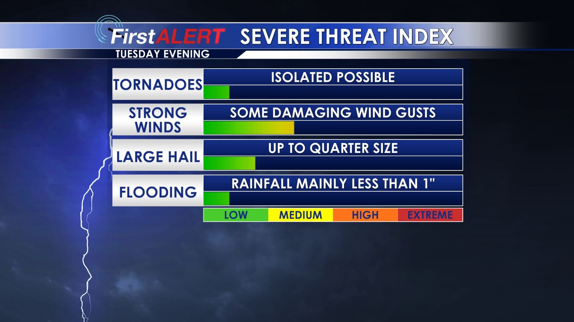
Severe Threat Tuesday Evening
MONDAY NIGHT: Variably to mostly cloudy tonight with a shower or two possible. Lows should be in the low 60s with southerly winds between 5 and 10 mph.
TUESDAY: Look for a warm and windy day with highs in the lower 80s. Rain chances are going to remain low through the afternoon.
TUESDAY EVENING/NIGHT: A line of fast moving storms is expected to cross our area from NW to SE. The current timing estimate in from about 7 p.m. in the NW and 1 a.m. in the SE. The main threat continues to look like damaging wind gusts an isolated tornado or some hail during the event. Lows should be in the upper 40s in the wake of the storms.
WEDNESDAY: Sunny but colder weather returns. Highs should range from the upper 50s to lower 60s. Breezy NW winds between 10 and 20 mph make it feel cool all day long.
WEDNESDAY NIGHT: Clear, calm, and cold conditions settle in. Lows in the mid 30s are a good bet and that means at least some patchy frost will be likely around here.
THURSDAY: Mostly sunny skies and seasonable upper 60s appear to be a good bet around our region. It should be a nice day to get things done outdoors once temperatures moderate from their morning lows.
FRIDAY: A cold front will move through but this one looks like it won’t produce any strong or severe weather. Widespread showers are likely going to develop during the day. Highs should remain in the 60s.
SATURDAY: Morning showers will yield to at least some sun during the 2nd half of the day. Chilly highs in the 50s may be the best we can do. Another frost is possible Saturday night with lows in the mid 30s.
SUNDAY: Bright sunshine returns along with seasonable temperatures in the upper 60s to around 70.
Follow @WCBIWEATHER on Facebook, Twitter, Instagram, and Snapchat


Leave a Reply