Strong Winds Today, an Isolated Tornado Also Possible
WATCH THE LATEST WEBCAST FORECAST HERE.
LEARN MORE ABOUT STAYING SAFE DURING SEVERE WEATHER HERE.
FIND OUT HOW TO DOWNLOAD THE WCBI MOBILE APP AND GET FIRST ALERTS SENT TO YOUR PHONE HERE.
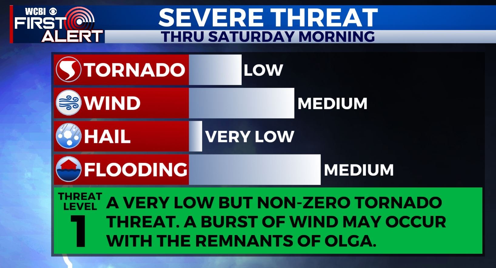
SUMMARY: Rain and storms are expected through the morning hours and perhaps into the early afternoon as well. By mid to late afternoon, rain will wrap up as this system lifts to the north. The main concern overall with this event will be flooding with storm totals over 4 to 5 inches in places but an isolated tornado or two can’t be ruled out this morning. The remnants of Tropical Storm Olga will also produce a spell of breezy winds with gusts over 30 mph. That combined with saturated soils may cause some tree and power line issues.
THIS MORNING: Look for strong storms to arrive into the area after 6 AM and lasting into the late morning and perhaps early afternoon hours. This last batch is associated with the core of the remnants of Olga. This batch will bring heavy rain back in, adding to our storm totals, which will likely end up in the 3-5″+ range, with some spots over 6″.
In addition, there is the threat for breezy winds with some guidance suggesting gusts may be as high as 40-50 mph plus. This combined with saturated soils would likely lead to fallen trees and poor driving conditions. In addition, with extra wind shear in place, an isolated tornado or two is possible, particularly along and east of US-45.
THIS AFTERNOON: As the remnants lift north and out of our area, we will still see breezy winds in the region slowly diminishing through the day. We may very well sneak in some sunshine in places and hold temperatures constant in the low 70s until close to sunset. Rain should be out of the region by 1 PM as drier air filters on in.
TONIGHT: Areas of low clouds and fog are likely. Lows near 50.
SUNDAY: Clouds and fog should eventually thin out giving rise to a nice afternoon. Highs should be in the upper 60s to around 70.
NEXT WEEK: Monday and Tuesday look like seasonal Fall days with highs in the 70s and lows in the 40s and 50s. Another system slides through by Wednesday into Thursday. This may very well lead to an additional chance for strong to severe storms on Halloween, but we’ve still got a bit of uncertainty looking forth. Once we head into November, odds are in our favor to see a chilly blast of cool air filter in, likely by Friday.
Follow @WCBIWEATHER on Facebook, Twitter, and Instagram and get the First Alert on the WCBI Mobile App.


Leave a Reply