Warm days this week lead to heavy rain potential Thursday
COLUMBUS, Mississippi (WCBI) – The last day of January and first few days of February bring mild conditions back to the region. Rain chances significantly increase Wednesday and Thursday.
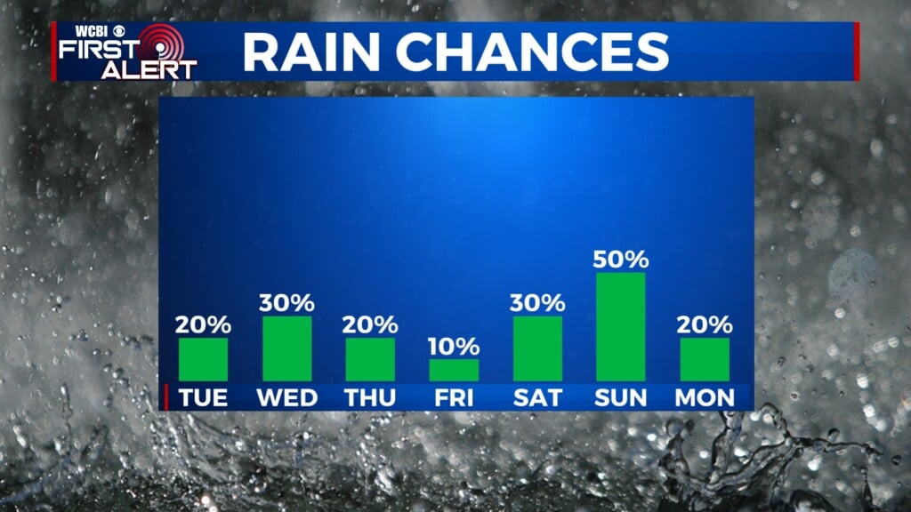
MONDAY: It will be hard to top Sunday’s weather, but today’s forecast looks quite similar. Expect plenty of sun with highs in the 60s.

TUESDAY: The day begins clear, but clouds will slowly increase through the afternoon and evening. Thanks to building moisture, a few showers could develop in the evening or overnight hours. Daytime highs will stay in the 60s.
WEDNESDAY: Showers become more likely as additional moisture moves into the region. While it won’t be a washout, expect a cloudy sky and on/off rain much of the day. Clouds and higher rain chances will hold highs down in the lower 60s.

THURSDAY: A strong area of low pressure and attendant cold front will be the day’s main weather makers. As it stands now, another surge of moisture will occur just ahead of the front in the afternoon. This could be enough for a low end threat for a few stronger storms south of US-82, but the occluding nature of the system suggests we might be spared from any significant threat for severe weather. However, heavy rain will impact the entire region, and some beneficial totals of one inch or higher look likely.
FRIDAY: Clouds will be slow to clear as chilly northwest winds pick up through the day. Highs will top out in the lower 40s with wind chills in the 30s much of the day.
WEEKEND: Sunshine returns Saturday, but it could be short-lived as another disturbance could bring additional clouds and possible showers by Sunday evening. Highs both days will be in the 50s.


Leave a Reply