Warmer starting Wednesday
SUMMARY: Heat and humidity will return as we head into the long Memorial Day weekend. Rain & storm chances will be with us just about every day going forward. No big weather maker is expected in our area any time soon.
WEDNESDAY NIGHT: Partly cloudy and still quite comfortable. Lows in the mid to upper 50s with light wind.
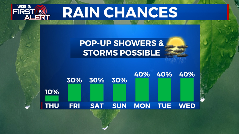
THURSDAY: Partly cloudy. Warmer highs in the low 80s. Southerly winds 3-7 mph. There is a slight chance of a shower but odds are 10% or less.
THURSDAY NIGHT: Variably cloudy with a chance of a shower or storm. Milder lows in the mid 60s.
FRIDAY: Variably cloudy, warm, and humid. Highs in the mid to upper 80s. A 30% chance of pop-up showers and storms
SATURDAY-MONDAY: Our Memorial Day weekend is going to feature plenty of heat and humidity. Daytime highs will be in the upper 80s to around 90 with overnight lows in the mid to upper 60s. Expect a 30-40% chance of pop-up showers and storms each and every day. Some of you may get a good soaking at times while other spots remain dry. No widespread severe weather is expected but any storm this time of year may produce gusty breezes, frequent lightning, small hail, and heavy downpours.
Follow @WCBIWEATHER on Facebook, Twitter, Instagram, and the WCBI News App


Leave a Reply