Weekend rain & storms coming
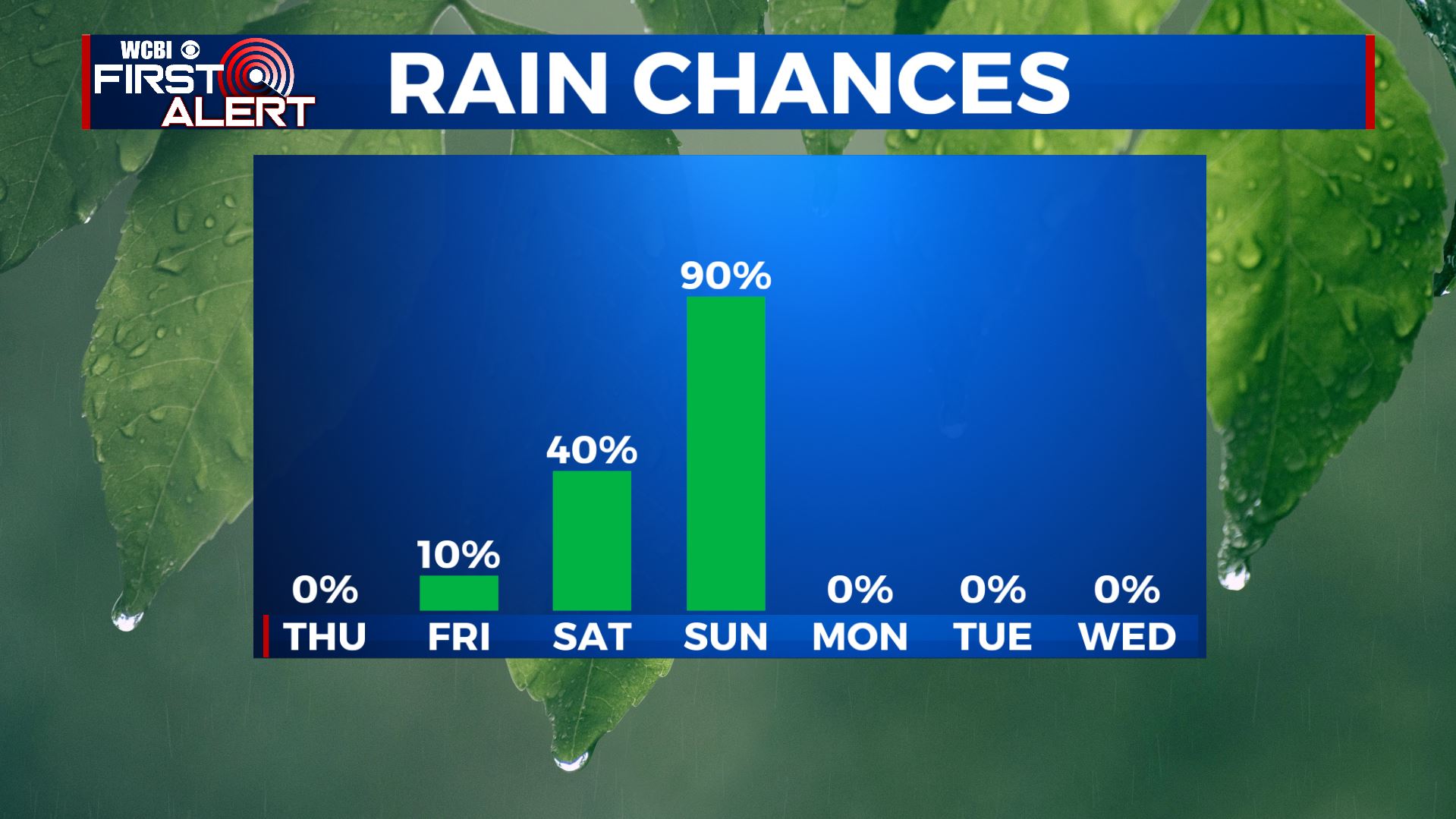
SUMMARY: Expect more clouds than sun for the rest of the week but rain chances will remain low through Friday. Our next best chance of rain will come Saturday afternoon through Sunday. There is the potential for some gusty storms Saturday night and Sunday morning if the atmosphere can become unstable enough. At this point it’s still in doubt but we’ll have to watch it since there will be ample wind energy in the atmosphere. Another 1/2” to over 2” of rain may fall this weekend.
WEDNESDAY NIGHT: Variably cloudy and mild. Lows in the upper 40s. Light SE winds 2-5 mph.
THURSDAY: More clouds than sun. Highs in the mid 60s.
THURSDAY NIGHT: Mostly cloudy. Lows in the low 50s.
FRIDAY: Mostly cloudy with a slight chance of a few showers. Highs in the mid 60s.
FRIDAY NIGHT: Mostly cloudy. Lows in the low to mid 50s.
SATURDAY: Mostly cloudy. A 40-50% chance of afternoon showers. Highs in the upper 60s.
SATURDAY NIGHT-SUNDAY AM: A batch of rain and storms is likely. Some gusty storms could develop if ingredients come together but it’s still uncertain. Temperatures look to hold in the 60s all night long.
SUNDAY: Areas of rain and storms. Some may be heavy, especially during the first 1/2 of the day. Chance of rain is 80%. Highs in the 60s. Total weekend rainfall between 1/2” and 2” or more.
MONDAY-TUESDAY: Cooler and drier air returns along with more sunshine. Highs fall back into the 50s with lows in the 30s.
NEW YEAR’S DAY: Clouds fill back in with rain showers developing. Additional heavy rain may become an issue depending how things set up. Highs in the low 50s.
Follow @WCBIWEATHER on Facebook, Twitter, Instagram, and the WCBI News app


Leave a Reply