Storms Pulling Away, Sunny Monday

Sunday Storm Reports
REST OF TODAY: The strong storms have pushed east of our coverage area. Rain will gradually taper off as the afternoon. The actual cold front will push through later this evening and there is always the chance of some additional develop. For the most part, our area is pretty much in the clear.
MONDAY: Mostly sunny conditions return along with cooler highs in the mid 70s. Look for lows in the 50s.
TUESDAY: Another nice day is on tap with mostly sunny skies and highs in the low 80s. Morning lows will be in the 50s.
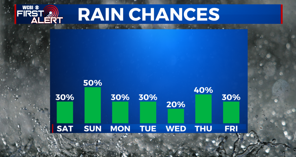
WEDNESDAY: Rain chances go up to 60% with a developing storm system. It’s too early to tell if strong or severe storms will occur in our area but it bears watching. Highs stay in the low 80s.
THURSDAY & FRIDAY: Cool and damp weather may settle for the end of the work week. Numerous showers are likely Thursday with more in the way of spotty activity on Friday. Either way you slice it our area may see some chilly days with highs in the 60s and day we say 50s Friday if some model solutions are right. We’re cautiously optimistic that the unsettled weather will move east by Saturday when the Market Street Festival in Columbus takes place. But for now, we’ll keep a 30% chance for an isolated shower.
NEXT WEEKEND: The general trend is that through next weekend, the trends are suggesting cooler and drier weather. We could have an isolated shower or two, but the heat and humidity looks likely to hold off through the weekend, perhaps even longer. It’ll be nice to get some cooler, drier weather in here to start May, as summer is just around the corner!
Stay connected with WCBIWEATHER on Facebook, Twitter, and Instagram


Leave a Reply